-
Video of Pattison State Park Campground – Superior, Wisconsin
©2015 John Wanserski for Creative Juice LLCMap of Pattison State Park (PDF file)
Map of Pattison State Park Campground (PDF file)
Map of Interfalls Lake, Pattison State Park (PDF File)
Blog entries for Pattison State Park
Weather forecast for Superior, Wisconsin vicinity
-
Westpoint Campground, Mondeaux Flowage, Chequamegon-Nicolet National Forest – Medford, WI
©2015 John Wanserski for Creative Juice LLCChequamegon-Nicolet National Forest
Map of Mondeaux Flowage (PDF file)
Mondeaux Flowage (DNR information site)
Blog entries for Mondeaux Flowage in the Chequamegon-Nicolet National Forest
Blog entries for the Chequamegon-Nicolet National Forest
Weather forecast for Medford, Wisconsin vicinity
-
Eastwood Campground, Mondeaux Flowage, Chequamegon-Nicolet National Forest – Medford, WI
©2015 John Wanserski for Creative Juice LLCChequamegon-Nicolet National Forest
Map of Mondeaux Flowage (PDF file)
Mondeaux Flowage (DNR information site)
Blog entries for Mondeaux Flowage in the Chequamegon-Nicolet National Forest
Blog entries for the Chequamegon-Nicolet National Forest
Weather forecast for Medford, Wisconsin vicinity
-
Spearhead Point and Picnic Point Campgrounds, Mondeaux Flowage, Chequamegon-Nicolet National Forest – Medford, WI
©2015 John Wanserski for Creative Juice LLCChequamegon-Nicolet National Forest
Map of Mondeaux Flowage (PDF file)
Mondeaux Flowage (DNR information site)
Blog entries for Mondeaux Flowage in the Chequamegon-Nicolet National Forest
Blog entries for the Chequamegon-Nicolet National Forest
Weather forecast for Medford, Wisconsin vicinity
-
Lower Scorpion Campground Tent Site, Gila Cliff Dwellings N. M. – Silver City, NM
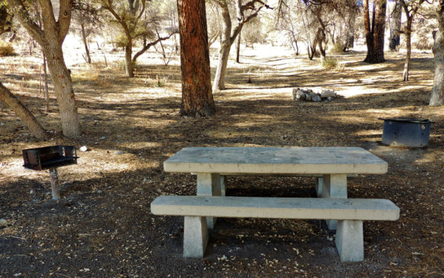
©2013 John Wanserski for Creative Juice LLCGila Cliff Dwellings National Monument
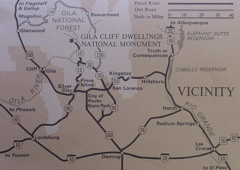
Map of Gila Cliff Dwellings National Monument
Gila Cliff Dwellings National Monument area map
Blog entries for Gila Cliff Dwellings National Monument
Weather forecast for Silver City, NM vicinity
-
Video of Otter Lake County Park and Campground – Stanley, Wisconsin
©2012 John Wanserski for Creative Juice LLCLakes, rivers, and streams of Chippewa County
Weather forecast for Stanley, Wisconsin vicinity
Blog entries for Otter Lake County Park
-
Video of North Campground Sites 1-40, Interstate Park – Saint Croix Falls, Wisconsin
©2012 John Wanserski for Creative Juice LLCMap of Interstate Park (PDF file)
Map of South Campground, Interstate Park (PDF file)
Weather forecast for the St. Croix Falls, WI
Blog entries for Interstate Park
-
Video of South Campground Sites 41-85, Interstate Park – Saint Croix Falls, Wisconsin
This video also includes the two group campsites.©2012 John Wanserski for Creative Juice LLC
Map of Interstate Park (PDF file)
Map of South Campground, Interstate Park (PDF file)
Weather forecast for the St. Croix Falls, WI
Blog entries for Interstate Park